New Events

International

no events posted in last week

Blog Feeds

Anti-Empire

Anti-Empire

offsite link This Site Will Soon Be Hosted at anti-em... Sun Sep 22, 2024 17:24 | Anti-Empire

offsite link Ukraine Shoots Down F-16 With Patriot, A... Sat Aug 31, 2024 11:53 | Anti-Empire

offsite link Surprise Offensive Puts 300 km² of Russ... Fri Aug 09, 2024 08:44 | Marko Marjanović

offsite link The Wholesome Photo of the Month Thu May 09, 2024 11:01 | Anti-Empire

offsite link In 3 War Years Russia Will Have Spent $3... Thu May 09, 2024 02:17 | Anti-Empire

Anti-Empire >>

Human Rights in Ireland
Promoting Human Rights in Ireland

Human Rights in Ireland >>

Lockdown Skeptics

The Daily Sceptic

offsite link News Round-Up Fri Oct 11, 2024 00:44 | Richard Eldred
A summary of the most interesting stories in the past 24 hours that challenge the prevailing orthodoxy about the ?climate emergency?, public health ?crises? and the supposed moral defects of Western civilisation.
The post News Round-Up appeared first on The Daily Sceptic.

offsite link Pay-Per-Mile Road Pricing is ?Inevitable?, Drivers Warned Thu Oct 10, 2024 19:30 | Will Jones
Motorists will "inevitably" end up paying per mile to drive on Britain?s roads as the switch to electric cars reduces fuel taxes, the Government?s infrastructure tsar has said.
The post Pay-Per-Mile Road Pricing is “Inevitable”, Drivers Warned appeared first on The Daily Sceptic.

offsite link State-Funded ?Anti-Hate? Organisation Run by Islamic Scholar Becomes Germany?s First Official Intern... Thu Oct 10, 2024 17:37 | Eugyppius
A state-funded 'anti-hate' organisation run by an Islamic scholar has become Germany's first official internet censor, empowered under the Digital Services Act to all but compel websites to delete the 'fake news' it flags.
The post State-Funded ‘Anti-Hate’ Organisation Run by Islamic Scholar Becomes Germany’s First Official Internet Censor appeared first on The Daily Sceptic.

offsite link Gas Power Prevented Blackout on Tuesday Thu Oct 10, 2024 15:21 | Paul Homewood
The U.K. only avoided a blackout on Tuesday because gas came to the rescue after a power line importing electricity from Norway failed. Under Net Zero we won't have gas to save us, warns Paul Homewood.
The post Gas Power Prevented Blackout on Tuesday appeared first on The Daily Sceptic.

offsite link BBC Weather App Predicts 15,000mph Winds in Oxford Circus and 404°C Temperatures Thu Oct 10, 2024 13:00 | Will Jones
The BBC Weather app incorrectly forecast winds of 15,000mph in Oxford Circus and temperatures of 404°C in Nottingham amid a countrywide software failure.
The post BBC Weather App Predicts 15,000mph Winds in Oxford Circus and 404°C Temperatures appeared first on The Daily Sceptic.

Lockdown Skeptics >>

Voltaire Network
Voltaire, international edition

offsite link Voltaire, International Newsletter N°102 Tue Oct 08, 2024 07:00 | en

offsite link Iran and Israel, by Thierry Meyssan Tue Oct 08, 2024 06:58 | en

offsite link Assassination of Hassan Nasrallah Tue Oct 08, 2024 06:50 | en

offsite link The place of the United States and Israel in the governments of the EU and Franc... Sun Oct 06, 2024 12:39 | en

offsite link Iran's letter informing of its attack on Israel in self-defense, by Amir Saeid I... Wed Oct 02, 2024 14:25 | en

Voltaire Network >>

A Most Amazing Henge - Lismullin

category international | history and heritage | feature author Friday May 11, 2007 11:32author by Muireann Ni Bhrolchain - Campaign to Save Taraauthor email info at savetara dot com Report this post to the editors

We told you so!

featured image
Lismullin's Temple

Experts had warned for years that the M3 should never have been routed through the Gabhra (Tara-Skreen) Valley.
What we refer to today as a “henge” are two related architectural forms that come from the late Neolithic and the early Bronze age. They date from about 2500 to 1800BC and may consist of banks, earth enclosures and also timber circles and that is what we have in this case. Rath Medb at is an example of the earthen enclosure. The best known henge is of course Stonehenge.

Related Links: Tara Watch submits DVD on Tara to Government. | Roestown national monument at Tara removed | Press statement from Campaign to Save Tara | Tara; The Inconvenient Truth by Martin Hogan, NUI Senate Candidate | Tara; The Inconvenient Truth by Martin Hogan, NUI Senate Candidate | Corruption Watch at Tara - Lets do some digging of our own

We told you so!
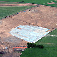
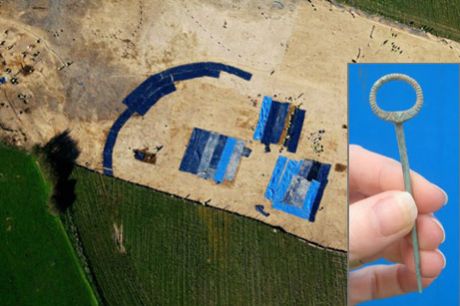
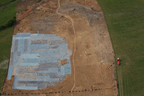
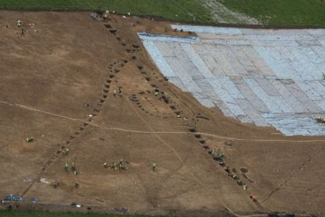
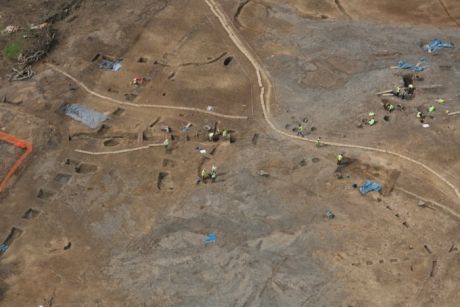
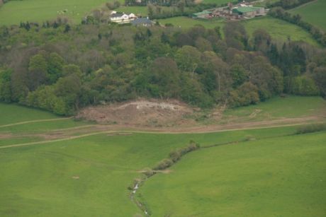
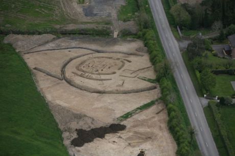
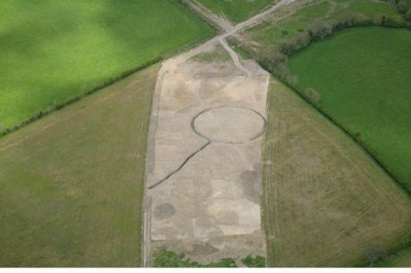
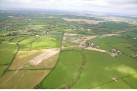
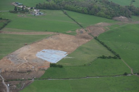
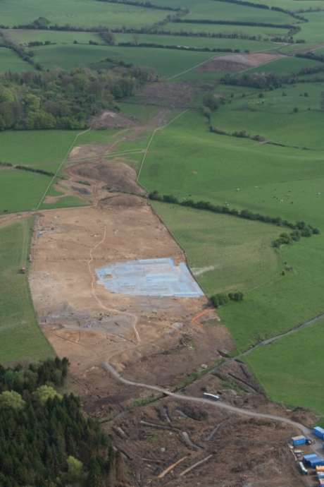
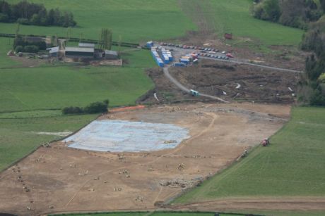
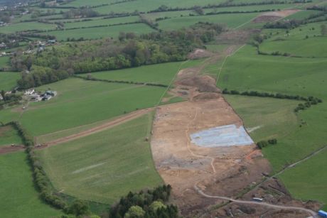
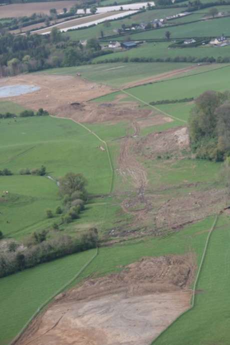
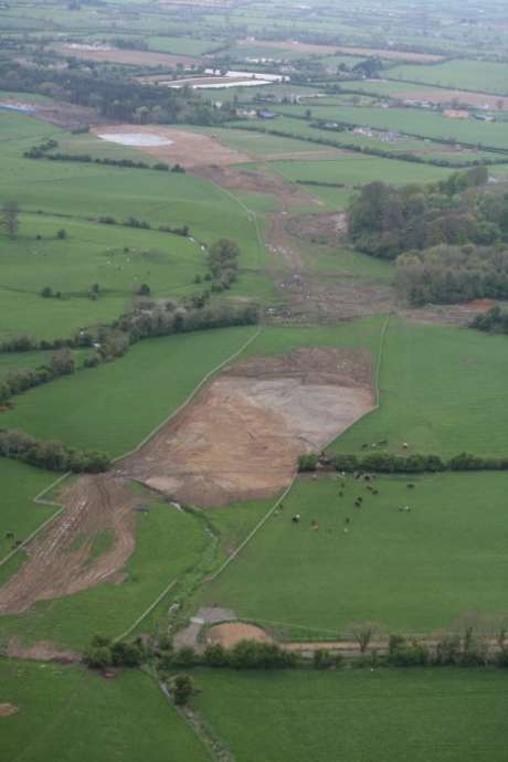
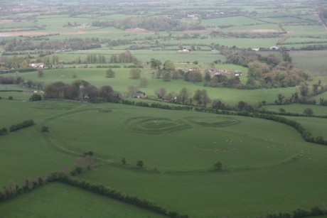
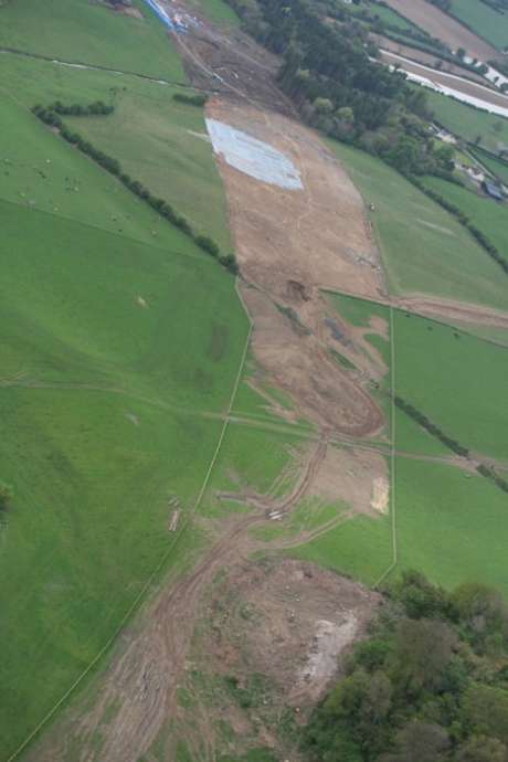
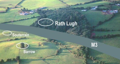
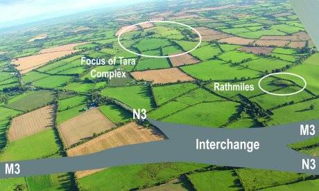
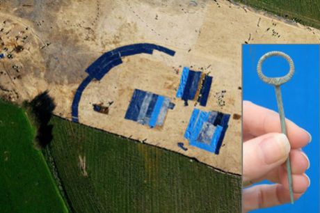
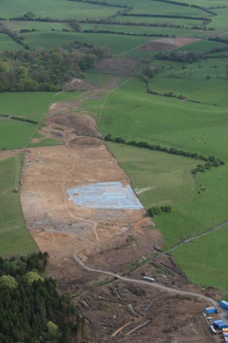
To explain the images: the two aerial shots were taken April 24th by Paula Geraghty for the Campaign to Save Tara - the area covered by blue plastic is the henge - the rest of the site in outside the road take and is on private property.
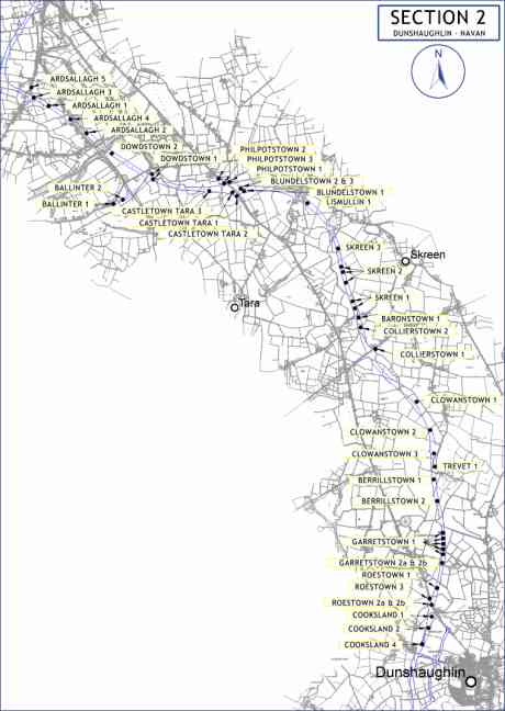
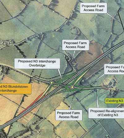
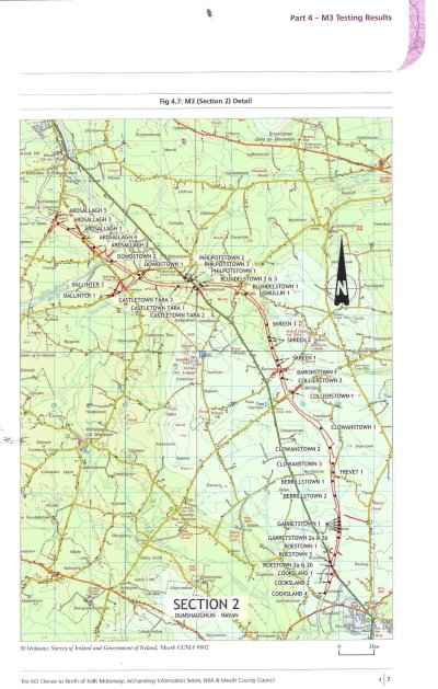
The other three images (below) come the website of Meath County Council.

The background
As far back as 1999 the NRA received advice from V.J. Keeley Ltd. in the document Archaeological Assessment Paper Survey, Preliminary Area of Interest N3 Dunshaughlin North to Navan West, Co. Meath. This said:

“In addition to being highly visible from the Hill of Tara, the route passes through the archaeologically sensitive landscape of the stream valley (ibid., 6.5.1.). No mitigation would remove the effects of this route on the Hill of Tara or on its outlying monuments. It would have extremely severe implications from an archaeological perspective.”

Then they were warned by Margaret Gowen Ltd. who said:

“The monuments around Tara cannot be viewed in isolation, or as individual sites, but must be seen in the context of an intact archaeological landscape, which should not under any circumstances be disturbed, in terms of visual or direct impact on the monuments themselves” (N3 Navan to Dunshaughlin Route Selection, August 2000, paragraph 7.3)
The same company advised the route selection company, Halcrow Barry:

“It would be virtually impossible to underestimate the importance or the sensitivity of the archaeological and historical landscape in this area” (Margaret Gowen and Co. Ltd., N3 Navan to Dunshaughlin Route Selection: Archaeology, August 2000, 3.1).

The Environmental Impact Statement said: ‘this section of the N3 runs through one of the richest and best known archaeological landscapes in Europe.’ (Vol.4A p.165). Conor Newman, expert on Tara warned on one occasion that the NRA would be: ‘tip-toeing through monuments and moving whack into them’.

Now the discovery, and further the declaration, of a National Monument at Lismullen vindicates those who campaigned for so long on this issue and said that sites in the Valley were related to Tara. There are other massive sites that have been discovered and downplayed by the NRA archaeologists and they will attempt to do the same with this one – just watch. Baronstown, Collierstown and Dowdstown should all be declared National Monuments – but of course the whole area is part of the National Monument of Tara.

What is a henge?
What we refer to today as a “henge” are two related architectural forms that come from the late Neolithic and the early Bronze age. That means from about 2500 to 1800BC and they may consist of banks, earth enclosures and also timber circles and that is what we have in this case. Rath Medb at is an example of the earthen enclosure. The best known henge is of course Stonehenge. There are both stone and wood henges and Lismullen is a wood henge. Stonehenge was built with wood before the more permanent stone structure was put in place. The timber circles can be quite different; there may be huge posts as was the case on the top of Tara or much smaller, slimmer ones as is the case with Lismullen. They can have multiple concentric rings as well single rings of post. Double rings appear to be more popular. But this one is, according to expert opinion, architecturally unique and it is middle-range size. The majority of henges in the world are found in Ireland and England. It can be seen from the diagrams produced by the NRA that there are three circles here, two large ones close together and a third, the inner sanctum, that is much smaller.

One of the oldest henges ever found is also in Meath, at Raffin Fort and this dates from c.3100BC and this was excavated by Conor Newman. Ireland is different from England in that these structures continued to be used well into the Iron Age and the latest timber circle is also found at Raffin, Co Meath and this dates the fifth century. This is the period of the arrival of Christianity to Ireland and it is significant that this henge was built at that time.

The Lismullen henge
What is particularly interesting about the Lismullen site is the description of the funnel-shaped entrance avenue that is a feature of early Iron Age ritual enclosures in Ireland. Similar examples are found at all the other important kingship sites in Ireland: Dún Áilinne (Kildare), Emhain Mhacha (near Armagh) and Cruachain (Connacht) and of course at the henge on top of the Hill of Tara. These are the primary ritual as well as the primary kingship sites of Ireland.

The site has been described as “quite amazing” by a leading authority. Conor Newman said in a press release issued on May 4 2007 by the Campaign to Save Tara: “This is a monument of major significance. It compares with Iron Age monuments found at the related royal sites of Emain Macha and Dun Ailinne, and a discovery of this magnitude in a landscape so heavily invested with ceremonial monuments was predicted from the start. The view expressed on MCC's website report that its position beneath the ceremonial complex on the Hill of Tara suggests that it may have served 'smaller or lesser political units' that might somehow have been skulking around the fringes of Tara is frankly asinine.”

The maps and other documents associated with this discovery can be seen on the Save Tara website under downloads and on the Meath County Council site.

Part of the Tara complex
Those who are expert in this area and in the area of Tara are of no doubt that this ritual site, really a temple, is part of the extended Tara complex. It is about 500metres from the area of Rath Lugh also flagged as being under threat of the motorway. This is the place about which there was such a furore in January. In the same area already flagged are a barrow and a souterrain. The NRA is trying to fit the road between these monuments – this was shown in photographs in the past.

This point in the Gabhra Valley is the entrance to Tara. It was more or less expected that a henge would be found in this location. They are usually associated with Passage Tombs. Conor Newman and Joe Fenwick recorded the existence of a straight line of Passage Tombs running from the river Boyne southwards right through the Gabhra Valley and up to the top of the hill. The Mound of the Hostages is surrounded by a henge also, this is 200metres in diameter and is much larger than the Lismullin Henge that is 80metres, still a very large area. These two henges are about the same distance apart as Knowth and Dowth are from each other. No one would doubt that the latter two are related to each other.

It is no accident that this henge is exactly where it is. The fact that Rath Lugh is situated at this position is no accident either. This tells us that from the very earliest times this area was considered as an integrated, cultural landscape and this continued right into the early medieval period.

The original dots on the maps are now extremely misleading as the sites expanded to such an extent that they are nearly backing one onto the other. The Lismullin site is nearly as far as Rath Lugh and the henge itself is approximately 500m from the Rath.

The Gabhra Valley
The Gowra (Gabhra) Valley lies between the Hills of Tara and Skryne. The valley is criss-crossed by little brooks fed by the springs around Tara and the Gabhra is one of these streams. The word gabhra comes from the word gabhar/gobhar that in Modern Irish means goat. But in the older language (c. 900) it also meant horse and especially a white mare so the name of the area translates as the Valley of the White Mare. The word appears in many other place names for example Ráth Gabhra. But the location is this place is unknown. Maybe this is what is now known as Rath Lugh? There is no reference to this place in early sources.

The famous Fianna had a battle in this area, known as the Battle of Gabhra. They were wiped out in the cataclysmic conflict. They fought the king of Tara, Cairpre the son Cormac mac Airt who was killed along with them. It is said in story and poetry that they were buried at the battle site along with the king of Tara.

For more information on the Gabhra visit the history section of the SaveTara website www.SaveTara.com
Related Link: http://www.savetara.com

Lismullin site with Rath Lugh in the background
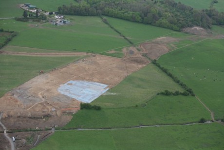

Closer view of the area
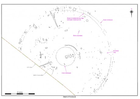

Details of the henge site
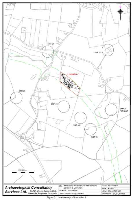

Geophysical detail in context
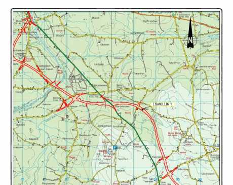

Lismullin on the map

author by Muireann Ni Bhrolchain - Campaign to Save Tarapublication date Mon May 07, 2007 19:10author address author phone Report this post to the editors

Here is the story of the Battle of Gabhra - where the legendary Fianna are said to have been destroyed - in this very landscape
Could Rath Lugh be the putative burial mound of the Fianna.

The Battle of Gabhra
Patrick asks Oisín: “What sad mound is this the holds such a long grave? Whose grave is this that is greater than the rest? Who is buried here? Whose grave is this that has been heaped so high?”
“My heart is filled with sorrow for the number of the Fianna who fell here … I do not want to tell the tale,” said Oisín.
“Do not be afraid and tell us story of the death of the Fianna,” said Patrick.
“That is the grave of Oscar son of Garaidh and of the graves of the sons of Morna,” said Oisín.
“Why are they buried here?” said Patrick.
“I have a story of the king of Tara and the Fianna of Ireland,” said Oisín.
The Fianna were at Almhu feasting when messengers arrived from Cairbre Lifechair the king of Tara son of Cormac mac Airt.
“The king want a gift from you the Fianna,” said the messenger. “And if you do not give it – you will be treated as rebels. You must grant him the hunting of all Ireland.”
“We would never give that away!” said Oscar. “We will give great battle to the king!”
Cairbre gathered together the army at Tara. Ulster, Leinster and Connacht helped him. His friend Oscar son of Garaidh came from Scotland. When Oscar arrived at Tara he did not find the king there and he went to Gabhair.
“Welcome!” said Cairbre, “and you have arrived in time to join in the battle with the Fianna!”
Cairbre and his army saw the Fianna approaching. On the Plain of Gabhair the king set a fence of shields and javelins around Oisín and the Fianna. They cast spears and swords at one another and many shields were smashed. Cairbre the king threw the spear at Oscar so that it flew through his body. But Oscar replied by cutting of Cairbre’s head with one huge, mighty blow.
“We had an army of ten hundred and three battalions at Gabhair,” said Oisín. “When the battle was over we had twenty hundred warriors. I watch their graves on the plain of Gabhair.”
“Where are the Fianna buried?” asked Patrick.
“Under the stone erected by Caoilte at Gabhair lie Mac Lughach and Oscar. Under the stone on the south of the steep hill lie two kings. Under the stone at Gabhair lies Cairbre Lifechair.”

Impact at Rath Lugh
Impact at Rath Lugh

Huge area covered by plastic

author by Muireann Ni Bhrolchain - Campaign to Save Tarapublication date Mon May 07, 2007 19:19author address author phone Report this post to the editors

The campaign to Save Tara took action for the media at Lismullin on May 3 2007. The event was captured by RTE News.
The campaign also sent out the following press release last week:

Arrogance and Ineptitude led to M3 Debacle

After the recent announcement of the discovery of a National Monument at
Lismullen, the Campaign to Save Tara is calling for any decision on the
future of the Henge to be postponed until the Election is over.
As far back as 2001 a Government funded research project reported that
the whole area around the Hill of Tara comprised a 'mosaic of monuments'
and should be considered as a whole and interconnected archaeological
landscape. During the preparation for the Environmental Impact
Statement, the NRA’s own archaeological advisors stated: ‘The monuments
around Tara cannot be viewed in isolation, or as individual sites, but
must be seen in the context of an intact archaeological landscape, which
should not under any circumstances be disturbed, in terms of visual or
direct impact on the monuments themselves.’ (Margaret Gowan and Co. Ltd,
Navan to Dunshaughlan Route Selection, August 2000, paragraph 7.3)
In his presentation to the An Bord Pleánala Oral Hearing (2002) Conor
Newman, ex-director of the Discovery Programme said: “… the valley
between Tara and Skryne is chock-a-block with archaeological monuments,
and interesting and complex ones at that: indeed it is a wonder that
with such results appearing at regular intervals along this route, why
was the whole route not surveyed.”
He said on the discovery of this present monument: “This is a monument
of major significance. It compares with Iron Age monuments found at the
related royal sites of Emain Macha and Dun Ailinne, and a discovery of
this magnitude in a landscape so heavily invested with ceremonial
monuments was predicted from the start. The view expressed on MCC's
website report that its position beneath the ceremonial complex on the
Hill of Tara suggests that it may have served 'smaller or lesser
political units' that might somehow have been skulking around the
fringes of Tara is frankly asinine.”
It is rather surprising that a site the size of Lismullen, where the
National Monument was uncovered, did not show up in the geophysical
survey but such examinations only reveal the tip of the iceberg as not
all archaeological features can be detected by geophysics. This advice
went unheeded by the NRA consultants at the beginning of this process.
Questions now arise as to the competence and rigour of the original
survey. For example, what other areas of the route through the Valley
have been inadequately surveyed or the survey results misinterpreted?
Michael Canney of the Campaign to Save Tara said: 'The Lismullen Henge
is undoubtedly a major find and its true significance lies in it
orientation and proximity to Rath Lugh and the Hill itself. There are
clear connections and all the evidence points to this being a major
monument located in a large and extensive 'Tara Complex', which extends
throughout the Valley.'
'The Government and the NRA rejected the Discovery Programme research
during the route selection process and now, three years and €40 million
in archaeological fees later, the motorists of Meath are faced with
further delays in delivering much needed infrastructure. If the
Government had read their own research, rather that favouring the
agendas of powerful local figures, the railway would be built and the
Tara Valley would have been given the recognition and protection it
deserves.'
In a related development Proinsias de Rossa MEP, will raise the matter
in the European Parliament on Wednesday next. The petitions committee of
the parliament has previously expressed concern about the proposed M3.
Mr. de Rossa is keen to ensure that all relevant EU legislation on
heritage is applied to the new National Monument. The Labour Party
Manifesto, published on Thursday last, explicitly sets out that it is
party policy to re-route the most controversial section of the route.
The Campaign to Save Tara is running an election campaign about the
Tara/M3 issue. They are seeking written assurances from all parties and
local candidates that they will re-route the road should they form part
of the next government. The campaign is urging its supporters to 'Vote
for Tara' on the basis of these written commitments.

Action for press and TV at Lismullin May 3 2007

The extent of the site

author by M. Ni Bhrolchainpublication date Mon May 07, 2007 20:10author address author phone Report this post to the editors

Apologies for putting up the wrong photograph earlier.

Impact at Rath Lugh
Impact at Rath Lugh

author by Michael Martin - Independent Tara Campaignerpublication date Mon May 07, 2007 23:20author email Wicklowwolf at yahoo dot comauthor address author phone Report this post to the editors

Press briefing and protest tomorrow. Everybody welcome. For further details click on
http://groups.yahoo.com/group/hilloftara/message/2904

Related Link: http://tarawatch.org
author by M3 for M3eathpublication date Tue May 08, 2007 12:00author address author phone Report this post to the editors

Isn't it very shocking all the same that our cuddly Celtic ancestors took down and abandoned this site. Or destroyed / burnt it? What does that tell you about its importance to them? It seems they are more important then us, their descendants.

Nearly as shocking as the 30m of our money spent on looking for this sort of (large) monument, which missed it? No apologies from the experts, then.

Can we have our road on stilts? Or re-routed through where? Using which 500 archaeologists this time?

Can someone remind us how many national monuments are listed? Over 100,000 at the last count.

author by Sharon D.publication date Tue May 08, 2007 12:10author address author phone Report this post to the editors

"Isn't it very shocking all the same that our cuddly Celtic ancestors took down and abandoned this site. Or destroyed / burnt it? What does that tell you about its importance to them? It seems they are more important then us, their descendants."

Yes, the colliseum, pyramids of egypt, parthenon and ancient babylon were also abandoned by their inhabitants and left to fall into ruin. We should tarmac over them and turn them into car parks, shopping centres and roads - it's obvious that they are of no importance and only anti-progress knockers could ever support the retention of such poor quality abandoned monuments.

On a more serious note, anybody who hasn't yet realised that the government are 100% responsible for the catastrophic lack of transport capacity on the N3 route really is wasting their brain. The campaigners predicted again and again that the chosen route was likely to encounter such historical sites. The government went with it due to their desire to please the landowners who got a fair few quid from CPOs. The rail service to Navan could have been completed years ago if they actually cared at all about the people of the N3 route - instead they just concerned themselves with jostling to get their noses in the trough and screw the people. "sure they're so thick they'll blame the hippies!" - and some of them are.

author by Roscommonpublication date Tue May 08, 2007 12:17author address author phone Report this post to the editors

Keep up the good work. Tara must be saved.
Our children will never forgive us if it is lost.
FF/PD know the price of everthing (twice what everyone else pays for it)
and the value of nothing.

author by HGpublication date Tue May 08, 2007 12:19author address author phone Report this post to the editors

Build the road over the henge using 500 archaeologists to hold it up

How many archaeologists does it take to change a light bulb on the m3?

501 - 1 to change the light bulb and 500 to hold up the road.....

author by Muireann Ni Bhrolchainpublication date Tue May 08, 2007 16:28author address author phone Report this post to the editors

According to local sources, the discovery was probably intended to be hidden. The site was damaged by the huge earthmoving equipment according to the same sources.
Blame the Government for this fiasco and then blame the NRA - who do not want hugely significant sites to come to light. They are an unelected quango - answerable to no one at all.
There is a lot more going on here than meets the eye.
The Viking town at Woodstown was hidden as well and its significance was downplayed.
This hengiform monument type is ONLY associated with ROYAL SITES.
This is no ordinary find - its extraordinary and goes to show that geophysical surveys cannot do the job that proper archaeology does - when sites are dug by hand as they should.
Massive earthmoving equipment has no business in an area like this and there were 5 of them at one point. Photos will follow.
The NRA are using the worst practice in this the most important area in our landscape instead of best practice.
Its an absolute disgrace.

author by hannahpublication date Tue May 08, 2007 16:59author address author phone Report this post to the editors

What role does DOELG have in this? their archaeologists are supposed to approve licence to excavate. has this been done?

author by Muireann Ni Bhrolchainpublication date Tue May 08, 2007 17:09author address author phone Report this post to the editors

The independent organisation on Irish heritage Duchas was dismantled by this administration.
The archaeologists were moved around and silenced to a great extent.
Then Minister Cullen changed the National Monuments act.
Yes, the licences were granted but this is the same company that hid Woodstown.
This administration has bullied everyone into silence, even the Archaeology Dept in UCD is funded by the NRA.
What this amounts is dictatorship with a complete erosion of democracy.
Tara is so important and they know this.
If this can happen at Tara - nowhere is safe.
Remember the adage "they came for the Jews and I did not speak up, they came for the communists" etc.
Then they came for me and there was no one left to speak for me.
If Tara is destroyed there will be nothing left to speak and everyone will have been silenced.

author by Muireann Ni Bhrolchain - Campaign to Save Tarapublication date Tue May 08, 2007 18:53author address author phone Report this post to the editors

PRESS RELEASE – Campaign to Save Tara

Campaign calls for full excavation of Lismullin/Rath Lugh area

Following the discovery of an unknown and unflagged National Monument on
the route of the M3 the Campaign to Save Tara is now calling on the NRA
and the Minister for the Environment to fully excavate the area between
Lismullin and Rath Lugh. The fact that the huge henge of Lismullin
remained undiscovered and unidentified by geophysical surveys and
test-trenching means that the NRA's archaeological surveys and
test-trenching results are highly suspect.

When test-trenching was carried out in 2004 the whole corridor was not
examined. The trenches were cut at regular intervals along the route but
the intervening areas remain untouched. Given that a completely new site
has been uncovered in the Colliertown area (as revealed by the Sunday
World, 6 May 2007 with aerial photograph) there are probably other sites that remain to be
discovered.

The Campaign is also asking that the whole motorway corridor now be
examined in advance of the beginning of construction and also that the top soil
taken from the existing sites, now lying in huge spoil heaps also be
examined by hand as demanded by best archaeological practice. The
Campaign to Save Tara is also seeking independent advice as to whether
the National monument found at Lismullen has been damaged by the use of
heavy earth moving equipment in contravention of best archaeological
practice.

For verification contact Muireann Ní Bhrolcháin 087-9249510

Related Link: http://www.savetara.com
author by Muireann Ni Bhrolchain - Campaign to Save Tara publication date Wed May 09, 2007 14:12author email muireann at savetara dot comauthor address author phone Report this post to the editors

To return to original thread here -
The work at Lismullin and Rath Lugh began in early January 2007 and the campaign and others drew attention to the fact that the area beside Rath Lugh was damaged and that the track of the motorway appeared to be very close to the Rath. Lismullin wood was savagely hacked down with indecent haste, so much so that a worker was injured by a falling tree. Work was carried out in dreadful weather conditions and under cover of darkness. This is accompanied by a series of photographs that were taken by various members of the campaign over a period of four months.
The earliest photograph shows that there was an awareness at a very early stage of an important site – bronze age pottery and flint in a find bag. This was however left out to the elements as the photo shows.

Indication of a bronze age site February 2007

Related Link: http://www.savetara.com
author by authur - plopublication date Wed May 09, 2007 14:22author address author phone Report this post to the editors

such things called catilist by ancient sparta----works like the oraoaclas---take into account population under influcence of war------regions there in-------------druid acctivetee---mans realshoinship with animals-----intellgence gatering of the nature of the lords stuff other lands --how to shift the tide not become the hen

author by Muireann Ni Bhrolchainpublication date Wed May 09, 2007 14:47author address author phone Report this post to the editors

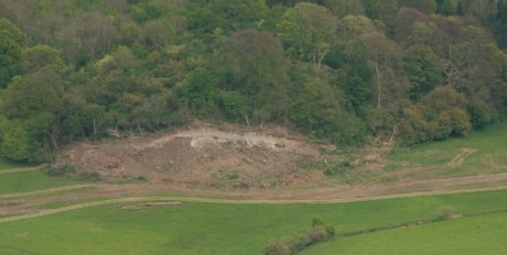
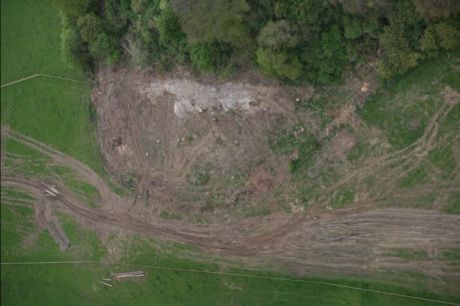
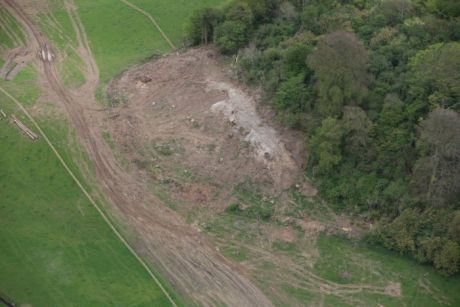
These are four photographs of the wooded area at Lismullin, very close to the henge. Huge diggers were used as can be seen. The massive depth was cut and trees felled without archaeological supervision until the Campaign drew this to the attention of the media and the Museum.

Here is a report from the Irish Times at the time, note what the NRA archaeologist Mary Deevy says:

Dr. Ní Bhrolcháin said standards of best archaeological practice were not being observed and that the directions issued by Mr. Roche in May 2005 regarding the treatment of archaeological sites "are being openly flouted".
But Mary Deevy, project archaeologist with the NRA, insisted that a site in a Save Tara photograph was part of an esker ridge - "two fields away from Rath Lugh" - which was used for private small-scale gravel quarrying.
She had walked from Lismullin to Rath Lugh earlier this month with Heather King, a senior archaeologist from the department, "who confirmed that no damage had been done to archaeological sites" in the area.
Asked if the Minister's directions were being flouted, Ms. Deevy said: "Absolutely not". She added that the contractors involved in the work were fully informed on archaeological sites "and know very well what sites to avoid".
Mr. Roche had specified that the removal of forestry and topsoil at Lismullin and Ardsallagh was to be "carried out under archaeological supervision" and all construction topsoil stripping was to be archaeologically monitored.
"There is no archaeological supervision of forestry clearance at Lismullin", Dr. Ní Bhrolcháin said. "Neither is there any archaeological monitoring of large-scale earthmoving from the base of the Rath Lugh escarpment".
"Such actions completely undermine Rath Lugh and the assurances given by the Minister in relation to this, one of our nation's most sensitive archaeological and historical landscapes", her statement said.
She explained that Rath Lugh "stands as a sentry over the Gabhra Valley guarding the northern and north-western approaches to the Hill [of Tara] and overlooks other nearby recorded archaeological monuments".
Dr. Ní Bhrolcháin said stratified archaeological sediments were visible in photographs of damage done to what she claimed was Rath Lugh. "If there were archaeological supervision such works would have been brought to a halt".
She also queried why such work had started under cover of darkness when an archaeologist would be unlikely to see freshly disturbed archaeological strata.
Although the Minister had said that his directions were "both comprehensive and onerous" and would "protect heritage" sites along the M3, Dr. Ní Bhrolcháin said that his expressed wishes "are being 'comprehensively' ignored".
© The Irish Times, 16th. January 2007.

So - they knew what sites to avoid. What about the henge? Did they know about that? Apparently not - not until late March-early April according to themselves.

Lismullin Wood February 2007

What hope for archaeology here?

Lismullin wood February 2007

Destroyi8ng Lismullin Wood

author by M. Ni Bhrolchainpublication date Wed May 09, 2007 14:53author address author phone Report this post to the editors

A spoil heap is the name used for the soil that is scraped away and left to one side. This is not examined by companies working on roads projects.
Many archaeological finds are found in this depth of soil. Not content with leaving the spoil heaps unexamined - they add insult to injury by driving the heavy machinery over the heap.

Spoil heap at Lismullin March 2007

Another view of spoil heap 30 March 2007

Lismullin site 30 March 2007

Digger marks at Lismullin 30 March 2007

Depth of initial cut Lismullin 30 March 2007

author by M. Ni Bhrolchainpublication date Wed May 09, 2007 15:20author address author phone Report this post to the editors

This piece of pottery was lying in the spoil heap in full view from the neighbouring field. Need I say more?
Some archaeology this. Hardly what they call best practice.

Bucket marks Lismullin 30 March 2007

Caterpillar marks Lismullin 30 March 2007

Spoil heap Lismullin 31 March 2007

Pottery found in spoil heap Lismullin 31 March 07

Same pottery again
Same pottery again

author by M. Ni Bhrolchainpublication date Wed May 09, 2007 15:31author address author phone Report this post to the editors

Here is the heavy machinery used at Lismullin. No wonder the NRA describe the area as "truncated" by ploughing as they were ploughing through the site.
This is March 31st - by April 4 they were reporting a National Monument to the department. I wonder why all of a sudden.

A find at Lismullin 31 March 2007

Huge machine at Lismullin 31 March 2007

Huge bucket used at Lismullin 31 March 2007

Heavy machinery Lismullin 31 March 2007

author by M. Ni Bhrolchainpublication date Wed May 09, 2007 15:39author address author phone Report this post to the editors

Photos taken on Sunday 1st April - the day that the Sunday World April Fool piece was published.
Little did Paddy Murray realise that it was about to come true!

Teeth at Lismullin 1 April 2007

Burial of what at Lismullin 1 April 2007

Depth of the cut Lismullin 1 April 2007

Henge area 1 April 2007

Lismullin find 1 April 2007

author by M. Ni Bhrolchainpublication date Wed May 09, 2007 15:44author address author phone Report this post to the editors

Now they know they have something. All covered up under blue plastic with little round stones

Aerial shot 24 April

Closer view 24 April

author by M. Ni Bhrolchainpublication date Wed May 09, 2007 15:52author address author phone Report this post to the editors

Here are close up views of the site from the ground taken on 29th April and 3rd May 2007.
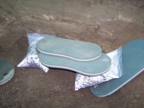
A dog was buried near the henge. His body was intact on 29th and he had been "bagged" as they call it by 3 May.
Dog burials are found at other ceremonial royal sites. Dog bones were found on Tara as well.
How long did he lie here undisturbed by ploughing to be ripped from the ground?
Dogs were considered sacred animals in early Ireland.

Henge site 29 April 2007

Canine burial 29 April 2007

Extent of henge site with cut wood in background 29 April 2007

Canine grave and henge May 3 2007

Respectful protest 3 May 2007

author by M. Ni Bhrolchainpublication date Wed May 09, 2007 15:56author address author phone Report this post to the editors

The campaign takes the opportunity to talk to the media who are really interested at last. Long may it last.
Thank you Tara for yielding up your most precious and sacred site just in time to make the world sit up and take note.
We were losing hope of you and you came to your own and to our aid with the perfect of timing .......

The campaigners
The campaigners

author by historianpublication date Sat May 12, 2007 01:30author address author phone Report this post to the editors

Great feature. Some decent, knowledge-based coverage badly needed. well done.

author by Mark Cpublication date Mon May 14, 2007 20:04author address author phone Report this post to the editors

Well done on a very well put together piece, keep up the pressure.

Mark.

author by Michael Canney - Campaign to Save Tarapublication date Mon May 14, 2007 20:35author address author phone Report this post to the editors

There are reports coming through tonight of heavy construction machinery being moved into the area around Colliestown in the Tara/Skryne Valley. The solidarity camp on the Hill are meeting tonight to discuss the significance of this and what action is to be taken.
Pictures and a statement from the camp will follow shortly.

PDF Document A 30ft banner was hung from the Drogheda suspension bridge last Friday morning 0.49 Mb


author by TaraWatchpublication date Wed May 16, 2007 03:28author address author phone Report this post to the editors

See article and link at (Other media) http://www.indymedia.ie/article/82583 or go directly to:
http://news.nationalgeographic.com/news/2007/05/070515-....html

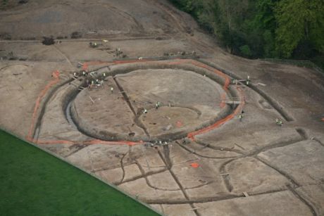
NRA aerial photo of temple from National Geographic article

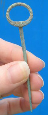
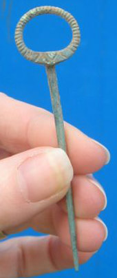
NRA image of pin found at temple site

Related Link: http://www.tarawatch.org
author by Debbie Reilly & Donagh Maguire - Tara Solidarity Vigilpublication date Wed May 16, 2007 12:16author address author phone Report this post to the editors

The Monkey Has Spoken

Yesterday Monday 14th of may construction by the NRA started in the Tara valley, 14 days after the sod turning of the controversial M3 and 13 days after a new national monument was declared in the valley.

Construction has started at Roestown with heavy machinery moving out of the compound heading north into the valley. There where 2 large diggers working in the fields between the compound located on the Dunshaughlin/ Dunsany road and the archaeological site at roes town 1 mile apx north of Dunshaughlin.

There where 4 huge dumpers sitting menacingly on the actual site of the souterrain complex at roes town which pat Wallace of the National Museum said “redefined the definition of a national monument…”.

They have already crossed the N3 and have pushed as far as the archaeological sites at garrets town. There were at least 1 digger and dumper working on the horizon with the usual entourage of high vis, steel toe-caps and mobile phones.

This is a blatant attack on the valley as they have started construction at the most controversial section of the entire route i.e. the valley of the kings.

Sites such as colliers town and barons town are in immediate danger with this rate of work, especially considering the grave stones from the cist burials at colliers town were removed and thrown into a pile at the edge of the archaeological site last week.

Do grave stones qualify as artefacts?

Half the site has already been tracked in ( east end of the site where second mound was located ). Bones and stones found in top soil used to fill site back in.

This treatment of the ancient graveyard at Collierstown and the fact that the souterrain complex at Roestown is being used as a car park for giant earth movers are examples of “archaeology by record” in action and dramatically illustrates the future of the newly found national monument at lissmullen if “bag it and tag it” is the decision taken by the powers that be. The level of devastation in one days work gives urgency to the situation.

We now call on all Friends of Tara to call her name and demand a halt to all work in the sacred valley. Daily demonstrations start immediately.

Don’t allow the Tara Valley become the Valley of Tar!

Let your voice be heard!

Come stand and be counted!

author by W. Finnerty.publication date Wed May 16, 2007 14:08author address author phone Report this post to the editors

I believe I must be just one of MANY who feel extremely grateful for the fact that there are people in the immediate area of the Hill of Tara to keep a sharp eye on developments, and report events in the way you are doing to the millions who (like myself) cannot be there.

Once ancient heritage sites are destroyed, they are destroyed forever.

"In order to contribute to the protection of the right of EVERY PERSON of present and FUTURE GENERATIONS to live in an environment adequate to his or her health and well being, each party shall guarantee the rights of access to information, PUBLIC PARTICIPATION IN DECISION MAKING, and access to justice in environmental matters in accordance with the provisions of this Convention."

The quote just above is the main stated "Objective" (Article 1) of the United Nations Aarhus Convention Agreement which the Republic of Ireland signed in 1998: and which, it spite of Article 29. 5. 1° of Bunreacht na hEireann (Constitution of Republic of Ireland), has still not been laid before Dáil Éireann.

Article 29. 5. 1° of Bunreacht na hEireann very clearly states:

"Every international agreement to which the State becomes a party shall be laid before Dáil Éireann." (Full text available via http://www.google.com/search?q=Bunreacht+na+hEireann&bt...earch )

Why is it that all (or almost all) of our "elected representatives" continue to completely ignore the wholly unconstitutional way that the Aarhus Convention Agreement is being handled by the Republic of Ireland - almost NINE YEARS years after it was signed on June 25th 1998?

Is it possible (I wonder) they are doing this, and lots of other things besides, to accommodate and facilitate the mind-bending "rip-offs" by the PPP (public-private partnership) swindlers - as described in articles such as the one at http://www.larouchepub.com/other/2006/site_packages/eco....html ?

And, if their completely unexplained tardiness, and TOTAL silence, regarding the matter of ratifying the Aarhus Convention is not connected with the PPP swindlers, what is it that's stopping them from doing what the people who vote for them so desperately now need to have done? - i.e. to enable "PUBLIC PARTICIPATION IN DECISION MAKING" for "EVERY PERSON".

My BIG hope now that RTE will vigorously include these issues (Aarhus, PPP, "public participation in decision-making", Tara, and Article 29. 5. 1° of Bunreacht na hEireann) in tonight's TV debate with the FOUR main opposition leaders (see http://www.rte.ie/news/2007/0516/election.html )

RTE were informed the day before yesterday about the above issues, as can be seen at http://www.europeancourtofhumanrightswilliamfinnerty.co...l.htm

Far more important perhaps, Minister for Justice Michael Mc Dowell TD was reminded (for the umpteenth time) again yesterday regarding the above issues, as can be seen at http://www.europeancourtofhumanrightswilliamfinnerty.co...l.htm

A final thought, which relates to the way Switzerland (just like the Republic of Ireland) is also failing to ratify the Aarhus Convention Agreement: might it have anything to do with the fact that doing so could conceivably threaten their very worrying "numbered accounts" business, which I assume must feature very strongly in PPP type activities?

Just a thought, and far be it from me to jump to hasty conclusions of any kind regarding Switzerland.

Related Link: http://www.constitutionofireland.com
author by Muireann Ni Bhrolchainpublication date Thu May 17, 2007 18:38author address author phone Report this post to the editors

Friends of Tara,
your support is urgently needed. NRA heavy machinery has moved into the Sacred Valley at Roestown moving north removing topsoil and filling archaeological sites.
Demo takes place tomorrow morning from 6am.
Tis time to take a stand.
Leaving Rath Lugh at 5.30am.
Please act now and pass this message on.
Thank you.

author by Muireann Ni Bhrolchain - Campaign to Save Tara publication date Thu May 17, 2007 21:59author email muireann at savetara dot comauthor address author phone Report this post to the editors

Here is a press release from the Campaign. I'm including the remainder of the aerial photographs taken by Paula Geraghty on 24th April. There are also two aerial shots taken of a new site near Collierstown - these were taken by the Sunday World and have been given free of charge to the Campaign to use. If using Paula's photographs please credit her.
Also found at the end is a detailed release from the Heritage Protection Alliance of Ireland

Campaign to Save Tara supports the Heritage Protection Alliance of Ireland

The Campaign to Save Tara welcomes and supports the announcement of the Heritage Protection Alliance of Ireland and their call to repeal the National Monument Act of 2004. Ireland had the best protection of heritage in Europe until Minister Cullen amended this act and effectively gave ministers the power to destroy National Monuments in order to facilitate the agenda of unbridled and unsustainable
development in the name of progress.

Archaeology must be taken back into the care of the state and away from the NRA and the private archaeological contracting companies that it employs. Dúchas, or a body of its kind, must be put in place with an independent voice for archaeology.

The practice of “preservation by record” is the order of the day and this is what faces the new National Monument at Lismullin. Why declare the appearance of a National Monument one week only to order its destruction the next? The Campaign to Save Tara asks that this site be fully investigated and then covered over and left in peace. The Campaign also asks that the whole area between it and Rath Lugh and its environs, including what used to be Lismullin Wood, be fully investigated by
independent archaeologists and not those associated with the NRA. The Campaign also demands that the full extent of the associated finds at Lismullin be given and published immediately by the NRA.

M. Ní Bhrolcháin said: “Tara is the line in the sand. If the Government are allowed to destroy Tara’s landscape then nowhere in Ireland is safe. The aerial shots taken by the Campaign clearly show that the whole Gabhra Valley is a monument and the road cannot be moved within it without destroying another possible National Monument. Sites such as Collierstown, Rowestown and Baronstown should also have been declared as National Monuments.”

Michael Canney said: "This new heritage protection alliance is absolutely necessary if we are to stop the increasing trend of seeing our heritage as a obstacle to progress; as some kind of inconvenience to a glorious concrete-covered future. The time has come, and the public are way ahead of the political classes in this regard, where we must
recognize environmental protection and economic development as a shared goal, because it is only through thoughtful management of our environmental and heritage resources, that future prosperity is guaranteed."

/////////////////////////////////////////////////////////////////////////

HERITAGE PROTECTION ALLIANCE of IRELAND

CHARTER May 2007

The Heritage Protection Alliance of Ireland is being founded in May
2007 to seek the repeal of the National Monument Act of 2004. This
Act extended the powers of the Minister of the Environment, Heritage
and Local Government, to allow for the destruction of archaeological
remains. The alliance seeks a strong National Monuments Act which
would ensure that real protection is afforded to what remains of our
archaeological heritage.

The past ten years have seen an unprecedented number of sites being
subjected to unnecessary destruction. Poor identification and
research at the planning stage have cost the taxpayer millions of euro
through unnecessary excavations which could and should have been
avoided.

The alliance members include professional archaeologists, historians,
senior academics and other experts and community leaders, including
Professor Donnachadh O' Corrain, Dr. David Edwards, Dr. Muireann Ní
Brolacháin, Dr. Padraig Lenihan, Rev. Brian Kennaway, and Senator
David Norris. Their combined professional experience and expertise
has led them to the conclusion that Irish archaeology and protection
given to heritage is in crisis. This is an issue which needs an
immediate response by any new government. The National Heritage has
been unnecessarily downgraded to facilitate development pressures and
this must be revisited.

During the past 10 years over 10,000 sites of archaeological potential
have been investigated in the Republic of Ireland under licence to the
Department of the Environment and Heritage. Approximately 70% of
these sites have tested "archaeologically positive", a phenomenal
number by any standards. To put this number in perspective, it should
be recalled that in 1989 a mere 101 sites were excavated.

In a period of rapid change, the cultural heritage of the country has
been subjected to an unprecedented policy of what is, essentially,
rescue archaeology. Sites which should have been protected, have
been perfunctorily excavated and reduced to "preservation by record" –
so frequently that this has almost become an acceptable practice in
itself. This in many cases should be re-named "destruction by
documentation".

Immediate reform is needed to halt this perfunctory excavation and
destruction of sites, monuments, and their curtilages - which has now
become almost a matter of routine. The current situation is totally
unacceptable.

There is now an urgent need to protect what remains.

The policy which has allowed the present situation to arise is
fundamentally flawed and unsustainable. It must be remembered
Archaeology is a finite resource, and the duty of the National
Government is to offer the utmost protection to this irreplaceable
resource.

Prior to this government's ill-advised amendment to the National
Monuments Act in 2004, the presumption was that "destruction by
recording" was an extreme measure that should be avoided. Since the
failure of the government of the time to prevent the destruction of
Wood Quay, Ireland's track record on the protection of our heritage
has been poor. The 2004 Act has reduced the status of archaeology to
the point where there is a development assumption, with lamentably few
worthy exceptions, and that now, excavation and recording is the norm
rather than the rarity.

The impact of the amendment has been devastating effect to local
communities, where resources which should have been used to develop
Heritage Tourism and Environmental Education have had to be diverted
into long and costly Court Cases and Bord Pleanala hearings. It is
to the credit of the community as a whole that, in so many areas,
strong and effective participation has prevented some of the worst
excesses of the current policy, and the community has been at times
supported by An Bord Pleanala in their efforts, often overruling the
local authorities' initial grants of permission.

The 2004 amendment must be repealed for the sake of the cultural
integrity of this island. A new policy must be formulated, and this
Alliance is seeking to place this issue on the agenda as a priority
for the next government.

The Monuments & Antiquities Committee of An Taisce welcomes the
formation of an alliance of professional experts and academics, in
partnership with local communities, and has offered a support role in
the development and co-ordination of the Alliance. A spokesperson
from An Taisce said that they fully accord with the need for a new and
effective policy in the National Interest:

"Individual communities have seen the erosion of the local vernacular
sites which define their towns, villages and landscapes, without
little recognition of their local knowledge or research. A common
experience is that when local knowledge indicates that a site is
important, it has not been sufficiently acknowledged by the Department
of the Environment, Heritage and Local Government, or the local
authority. This situation has served no one.

Developers have been subjected to astronomical costs in "resolving"
archaeology, which is then passed on to the public and business sector
– while communities have struggled to raise funds to hire
archaeologists, lawyers, and planners to try and do what is the
state's responsibility – to identify and protect our heritage.

National infrastructure projects have been delayed because archaeology
becomes an issue late in the day, because basic research has not been
conducted and routes for roads which were ill advised in the first
place are at great expense and delay, eventually re-routed or built at
a price that is no longer acceptable. It is sad but true that
taxpayers are paying for the destruction of heritage they wish to see
protected, in the name of progress."

Some sites have been totally destroyed through lack of proper planning
at initial design phase. Consultant archaeological companies are
perceived to be "developer-led", and are believed by many communities
to have "fast tracked" excavations. Local Area Plans and re-zoning
issues have proved, in many instances, to have been developer-led, and
failed to include local history organizations reasoned submissions in
relation to heritage.

A solution, where appropriate, would be to create a levy on new
development which provides an archaeological process independent of
the developer, and prior to any planning application. A strong
independent National Monuments Advisory Body should be reinstated.
Permanent protection to the archaeological heritage and landscape must
be enshrined in new legislation. We cannot undo the destruction that
has occurred, but we can seek to end it.

Non-intrusive techniques and the historic record alone could have
protected many sites which now exist as a paper record only. The
establishment of a robust register of sites of vernacular importance
in each settlement area, to augment the power of the present Sites and
Monuments Register/County Development Plans is long overdue. It is
the landscape and history of each town and village which gives it it's
unique identity, and it is this that has been lost in many instances.

It has been a pattern in Irish life and politics that abuse is
recognised only in retrospect. Our capacity to deal with it is
hindered by the lack of decisive intervention even after it has been
acknowledged. We are asking our future political leaders to take
responsibility and pledge commitment to a protection of our now very
damaged archaeological heritage landscape and support the thousands of
individuals who want reform.

We are looking for a government that recognises that what has happened
is disgraceful, and that takes the time to explore and cherish what is
essentially Irish.

CASE STUDIES

The Heritage Protection Alliance of Ireland has identified the
following sites as case studies where the policy as defined by the
Planning Acts has been inadequate and in need of further protection.
The various organizations who have identified and defended these
sites, and their professional experts are committed to a reform of the
planning acts to provide an integrated policy for the protection of
the archaeological heritage and landscape of Ireland.

Alliance membership includes professional archaeologists, architects,
academics and local community groups who are or have been instrumental
in protecting or attempting to protect the following sites:

TEMPLE SITE, TARA-SKRYNE VALLEY, CO. MEATH

The discovery of a sacred Temple site at Tara (of the High Kings) is
one of the most significant archaeological discoveries in these
islands in the 21st Century. The public was not informed for a month
after its finding, and no attempt has been made to involve the
international archaeological community in this extraordinary
development. The circular enclosure has a remarkable diameter of 80
metres.

A wooden post circle is reminiscent of discoveries at Emain Macha
(seat of the ancient Kings of Ulster) and Dun Ailinne (seat of the
ancient Kings of Leinster); a National Monument without question, and
one totally deserving of preservation. This site should have been
identified prior to any road plans being drawn up. It is
incomprehensible, given the technologies available, that it was not.
An appeal by An Taisce awaits hearing in the Supreme Court.

VIKING LONGPHORT SITE, WOODSTOWN, CO WATERFORD

A Viking longphort site - in essence the site of early Waterford city.
National Monument belatedly declared. Intrusive archaeological
testing led to the destruction of large parts of the site, and
contrary to all best practice, Viking objects were found and removed
from soil dump. The alarm was raised only when young archaeologists
expressed concern. The opportunity to place this site in the
research corpus of international Viking sites was lost.

KILSALLAGHAN HISTORIC LANDSCAPE, CO. DUBLIN

Complex of sub-surface monuments at the heart of a largely intact
prehistoric into medieval landscape. Proposed super-prison, (the
largest in Europe), combined with the Central Mental Hospital.
Decision to buy land based on "incomplete, inaccurate, and misleading
information". Lack of proper impact study undertaken prior to the
purchase of the site. Local residents ignored and deemed not worthy of
consultation by the relevant Minister. This coupled with new
legislation, designed to allow the government to build no matter what
the retrospective Environmental Impact Assessment uncovers. High Court
proceedings have been re-initiated.

BATTLE OF THE BOYNE SITE, CO. LOUTH/ MEATH

A site, which under international heritage conventions, would have
been preserved intact. However at present there is a proposal to build
a so-called "eco-friendly" hotel immediately adjacent to the place of
King William's wounding during the battle! A "strongly worded" letter
sent by the OPW to Co. Louth planners (Febuary 2006); How about
outright refusal? An Taisce has filed an objection.

TRIM CASTLE, CO. MEATH

A proposal to build a hotel immediately across the narrow street from
the perimeter wall of Ireland's most impressive castle. Despite the
views of Department of Environment archaeologists, and other concerned
professionals to reject the proposal, the experts were over-ruled and
the hotel was built by consent of the Minister for the Environment of
the day.

ROUND TOWER, CLONDALKIN, CO. DUBLIN

Proposal to build a bar/restaurant immediately adjacent to the Early
Christian Round Tower! Resisted successfully thanks to the efforts of
the local residents and the cross-party co-operation of the elected
representatives(2005).

AUGHRIM BATTLEFIELD SITE, CO. GALWAY
Major battlefield in the 1690s Williamite/ Jacobite war, t he Aughrim
battle site is under threat from the proposed motorway which cuts
through the left flank of the Irish position to the north of Aughrim
village. The integrity of the rest of the site and especially the
Jacobite lines on Aughrim Hill has been and is being degraded by house
building. Galway County Council refuses to recognise the need for any
controls over building in the core of the battle site. The contract to
build the road was agreed last month (April 2007).

HILLFORT AT RAHALLY, CO. GALWAY

A trivallate hillfort of exceptionally rare form. Diameter of 400
metres. Omitted from Environmental Impact Assessment. Topsoil within
perimeter mechanically removed, which is contrary to best practice;
hardly any topsoil finds! This is part of the route for the proposed
M6.

BLACK PIG'S DYKE, CO. CAVAN & ULSTER

An ancient defensive barrier believed to have once stretched from
Armagh to Donegal, dating from around 100 BC and, according to
Professor Donnachadh O' Corrain of UCC, is "monumental evidence to the
type of accounts given in the Tain Bo Cuilleanna," - the ancient myths
which feature Cucullen and the saga of the Brown Bull of Cooley.
Last year Cavan County Council considered an application by a quarry
company to expand their operation at an area in which the last
surviving section of the dyke in Cavan is sited. The company has
already destroyed a 220 metre section of the dyke since they began
quarrying there in the mid-1970's; the only arrest on this
environmental brutalism has been through the efforts of local
voluntary heritage interests.

PREHISTORIC-MEDIEVAL LANDSCAPE, RATHDOWN, CO. WICKLOW.

This landscape includes Rathdown Castle and St. Crispin's Cell;
continuous settlement from prehistoric times, with a complex
multi-period series of sites and remains. One of the few landfall
sites remaining in the country intact, on the slopes of Bray Head, and
one of the most important deserted Medieval sites in Ireland.
Located in the Barony of Rathdown, home of the MacGillaMcolmogs and
other Leinster Chieftains, its landscape has survived almost intact on
the costal strip. Gave its name to present administrative area of Dun
Laoghaire-Rathdown.

The protection of the Rathdown site has been ongoing over the past 17
years, involving the local community in numerous planning appeals.
Most of the site has been preserved, but some unnecessary loss
occurred, after trial trenching failed to identify significant
prehistoric settlement (Beaker period) and an Early Christian
corn-drying kiln.

The present proposals for a Marina and c.350 apartments now with An
Bord Pleanala, has confirmed substantial archaeology on the 'Castle
Bawn' field to the south of the present 24 acre National Monument.
The developers propose to use almost all of the field for a merely
temporary industrial facility to facilitate the works. The original
planning application by Wicklow Co. Council disregarded the wealth of
information about the site already on their files, and objections on
heritage grounds were ignored. The destruction of national heritage
to serve temporary works is incomprehensible.

CARRICKMINES CASTLE & MEDIEVAL SETTLEMENT, CO. DUBLIN

Unique revetted fosse with a well-documented history. Declared a
National Monument only after Court action. Destruction directed by
the Minister for the Environment after the National Monuments Act had
been downgraded in 2004. All future major discoveries are accordingly
put in jeopardy. The unanswered question posed by Judge Flood in the
Tribunal – "who decided to move the site of the interchange onto the
known castle site?" Answer by the relevant authorities was "can't
remember"; an answer described by Judge Flood as "unimpressive". It
is believed this junction, the 4th in a 9 kilometre stretch of the
M50, was designed, and specifically the roundabout, to facilitate the
opening up of the rezoned lands that belonged to Jackson Way.

CARRIGAPHOOCA CASTLE, MACROOM, CO. CORK

Carrigaphooca Castle; until now one of Irelands best kept Hiberno
Norman Tower-houses, sited in an outstanding setting. This demesne
is listed in the National Inventory of Architectural Heritage category
on historic gardens and designed landscapes. It was from this castle
that Justin MacCarthy, Lord of Muskerry and Carrigaphooca, led the
first Irish brigade to France. WB Yeats included a story from the
castle in his collection of Irish Faerie Tales.

The current plan for Carrigaphooca Castle, manor house, and nearby
pre-historic stone circle, is to slice through this demesne by placing
a four-lane highway and two flyovers less than 200 metres from the
castle door - thus obliterating the entire setting of the castle, the
remnants of its bawn, and manor house. An outrageous proposal that
should never have been considered in the first place.

The Alliance is concerned at the dilapidation and possible destruction
of a number of heritage buildings, their settings, and historic and
architectural potential:

16 MOORE STREET, DUBLIN CITY

The location of the last documented headquarters of the 1916
Provisional Government. Twice scheduled in the City Development Plan
for protection – and yet the roof was being let collapse in on what is
now a derelict building. As with Clondalkin, the only reason the
building is being saved is through the voluntary efforts of community
response– and as such there are yet uncertainties as to the ultimate
fate of the building in question, with the designation of it being a
National Monument under challenge.

12 DORSET STREET, DUBLIN CITY

The remainder of the birthplace of the playwright Richard Brinsley
Sheridan, who authored "The School for Scandal", amongst other works.
In the last few months Dublin City Council has granted permission –
currently being appealed – to demolish and replace this supposedly
"protected structure" with a block of flats.

1 MOUNTJOY SQUARE, DUBLIN CITY

A house of significant cultural importance. Left neglected and
empty with deadbolts on the front door, this house had been in the
charitable hands of a religious institution until it was sold a decade
ago. Subsequently sub-divided and let out in multiple occupancies, a
fire occurred at the house last Christmas (December 2006). This was
a location of Dail Eireann which met here during 1919 and 1920 when
owned by Alderman Walter Coles, who also let Michael Collins use of
the address as a safe house during The War of Independence.
Previously it had been the residence of Home Rule MP T.M. Healy, and
prior to that had been residence to Archbishop Hawksley.

GREYSTONES HARBOUR, CO. WICKLOW

The department of the Environment has conceded the destruction of the
19th Century South Pier in Greystones harbour, and acceded to
proposals which will open up development possibilities on every soft
shoreline in the country. Wicklow Co. Council has refused - despite
strong local objections to re-zoning and planning - to accord
Architectural Conservation Area status to the harbour area, one of the
finest Victorian landscapes on the East coast, which includes 14
protected buildings whose setting will be irretrievably damaged by the
Marina Proposals.

CONCLUSION

In every corner of this island, there are concerned citizens involved
in protecting what is essentially our collective identity. The
Heritage Protection Alliance of Ireland seeks to provide a platform
and a forum in defence of the history, cultures, and integrity of the
island.

In the context of a general election in the Republic it is of great
interest and concern to a sizeable proportion of its citizens to know
just where exactly the respective political parties stand in relation
to heritage and more importantly its protection.

It is the intention of the Heritage Protection Alliance to seek formal
meetings with the relevant spokespersons of the respective parties.
The individual reactions/ pronouncements of the parties shall then be
made public.

There has been a consistent pattern to date, which is no longer
acceptable. The scale, losses and destruction of our built and rural
heritage has reached a point where it is vital that a new policy is
devised which protects the fragile remains of our settlements and
architectural and archaeological landscapes.

The pattern is one of systematic destruction of the physical
manifestations of our collective history and cultures on the island of
Ireland. In the cause of citizenship and democracy, it is time to
re-instate the onus back upon the taxpayer-funded state bodies to
protect the physical heirlooms of our unique and shared cultures.

HERITAGE PROTECTION ALLIANCE of IRELAND – SPOKESPERSON PER SITE:

Tara ancient seat of High Kings – Dr. Muireann Ní Brolacháin.
Tel: +353 87 924 9510 Email: muireann@indigo.ie

Woodstown Viking site - Professor Donnachadh O' Corrain.
Tel: +353 86 832 7202, Email:
ocorrain@ucc.ie

Kilsallaghan Historic Townland, Co Dublin - Teresa McDonald
Tel: +353 85 722 5659,
Email: info@residentssayno.com

Boyne battlefield site - Rev. Brian Kennaway.
Tel: +44 7778 998 115,
Email:bkennaway@presbyterianireland.org,
Dr. Padraig Lenihan Tel: +353 91 527 003,
Email: padraig.lenihan@ul.ie

Trim Norman Castle - Councillor Phil Cantwell.
Tel: +353 87 288 0288,
Email: pcantwell@members.meathcoco.ie Rathdown Prehistoric and

Medieval settlement, Greystones Victorian Harbour :Emer Singleton.
Tel: +353 871 151 949, Email: info@rathdown.com

Carrickmines Medieval Settlement - Ruadhán Mac Eoin,
Tel: +353 86 814 6077, Email: ruadhan.maceoin@gmail.com

Aughrim battlefield site - Rev. Brian Kennaway.
Tel: +44 7778 998 115,
Email:bkennaway@presbyterianireland.org ,
Dr. Padraig Lenihan Tel: +353 91 527 003,
Email: padraig.lenihan@ul.ie

Carrigaphooca Castle, Macroom, Co Cork – Dr. David Edwards. +353 86
161 9866, Email: d.edwards@ucc.ie

16 Moore St, Dublin, HQ of 1916 Provisional Government - Dominic
Dunne. Tel.: +353 85 7387565,
Email: domodun@gmail.com

12 Dorset Street, Dublin, birthplace of Brinsley Sheridan – Senator
David Norris. Tel: +353 1 618 3333,
Email: info@senatordavidnorris.ie

1 Mountjoy Square – Michael Smith.
Tel: +353 1 873 5824, Email: michaelsmith@eircom.net

CO-ORDINATORS:
Dr. Mark Clinton. +353 85 109 2473,
Email:norahbk@eircom.net
Ruadhán Mac Eoin Tel: +353 86 814 6077,
Email: ruadhan.maceoin@gmail.com

Baronstown April 24 2007

Close up again at Lismullin April 24 2007

Close up Lismullin April 24 2007

Close up of Lismullin site 24 April 2007

Close up at Rath Lugh

Related Link: http://www.savetara.com
author by Muireann Ni Bhrolchainpublication date Thu May 17, 2007 22:14author address author phone Report this post to the editors

Photograph of Collierstown from the sky - obviously this should also have been declared as a National Monument as well as Baronstown. The extent can really only be appreciated from this angle.
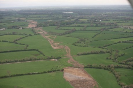
The new site is shown in close up, the wider shot shows the new site to the foreground. One field away, to the right is Collierstown, just behind that is the second Collierstown site, after that is Baronstown and from that the photo extends up as far as Lismullin.
This is the landscape of Tara, this is a mosaic of sites.

Collierstown April 24 2007

Close up of a new site April 7 2007

New site in context April 7 2007

Closer view Lismullin and damage at Rath Lugh April 24 2007

Lismullin and Rath Lugh in background April 24 2007

author by Muireann Ni Bhrolchainpublication date Thu May 17, 2007 22:23author address author phone Report this post to the editors

These photographs show the area of Lismullin from various angles. This is linking up with the next series of sites at Skryne.
Some of these are only a field apart. Remember that the whole route was not investigated from the beginning - the woods at Lismullin have not been surveyed, the area under the carpark used by the workers has not been investigated so we still do not know how many more hidden sites lie in these areas waiting to be revealed.

Edge of Rath Lugh area April 24 2007

Extent of the road take April 24 2007

Lismullin and cut wood April 24 2007

Lismullin and Rath Lugh to Skryne April 24 2007

Lismullin from the Skryne direction April 24 2007

author by Muireann Ni Bhrolchainpublication date Thu May 17, 2007 22:30author address author phone Report this post to the editors

The photograph of the hill itself shows the archaeological sites in the background, this is the site of the planned interchange - that is how close they are.
These also show the road impact at Rath Lugh - has the road moved?

Rath Lugh close up 24 April 2007

Road take at Rath Lugh 24 April 2007

Skryne Rath Lugh Lismullin 24 April 2007

Tara looking towards interchange site 24 April 2007

Towards Lismullin 24 April 2007

author by Muireann Ni Bhrolchainpublication date Thu May 17, 2007 22:45author address author phone Report this post to the editors

And let us finish with the photographs that were taken at the beginning showing the impact of the road - and how can the road be moved around the henge with the Lismullin area with the other surrounding monuments?
The way in which the sites are shown on the NRA map is now completely misleading as these photographs show. They are no longer the little tidy dots spread apart but have extended so far as to run into one another as was predicted.

NRA map of sites
NRA map of sites

Impact at Rath Lugh
Impact at Rath Lugh

Interchange at Tara
Interchange at Tara

Impact at Tara
Impact at Tara

Chosen route
Chosen route

author by Muireann Ni Bhrolchainpublication date Thu May 17, 2007 22:50author address author phone Report this post to the editors

This is the NRA's official aerial shot of Lismullin.
And a pin - this is the only find that they thought worth releasing. This despite the find of a dog burial and rumours of other very interesting finds and burials.
Dogs were totemic animals in early Ireland, dogs have been found at similar royal sites in the country.
Either the NRA don't know how important this is or they are trying to downplay this site as well as all the others.
Why are certain archaeologists trying to say that the burial was a badger?

NRA aerial of site
NRA aerial of site

A pin
A pin

author by Campaigner for Tarapublication date Fri May 18, 2007 09:46author address author phone Report this post to the editors

There are protesters at Roestown facing the construction workers. Huge machinery in the Valley.
Guards are present - just the beginning.

author by W. Finnerty.publication date Fri May 18, 2007 23:32author address author phone Report this post to the editors

I'm delighted to learn of newly formed "Heritage Protection Alliance of Ireland".

One of the sites on the above list, the "HILLFORT AT RAHALLY", is located near my home in County Galway, and I would like to point out that there are several other ancient heritage sites in this particular area under serious threat from the planned N6 Upgrade, apart from the one mentioned at Rahally.

The ancient heritage sites I have mostly in mind are part of the huge set associated with Turoe & Knocknadala (Iron Age "Hill of Parliament") complex, which has at its centre the world famous Turoe Stone (see http://homepage.eircom.net/~williamfinnerty/protest/nov...e.htm ), and which many well-informed people believe is the most important (by far) piece of Celtic stone-art in the world.

Using information on the Turoe & Knocknadala complex which I received from research scientist Dr Kieran Jordan, I informed several government ministers about this Iron Age "Royal Centre", including Prime Minister Ahern, on March 5th 2001. For irrefutable evidence of this, please the set of five Post Office registered letter receipts at http://homepage.eircom.net/~williamfinnerty/kj1.htm .

Later, when all of the senior public officials referred to in the paragraph just above appeared to be completely ignoring Dr Jordan's information, I sent a petition to the European Parliament on September 22nd 2003, which can be seen at http://www.finnachta.com/EuropeanParliamentPetition.htm .

Part of the European Parliament's reply to my petition, i.e. their letter dated October 21st 2004, ended with the following two sentences: "The planning and design of this project has received support from the Regional Development Fund. However it is not expected that the construction of the project will be funded". (The full European Parliament text is on view at http://www.constitutionofireland.com/EuropeanParliament...3.htm ).

I wonder if this means that one or other of the "PPP (public-private partnership) swindlers" mentioned at http://www.larouchepub.com/other/2006/site_packages/eco....html will now be "funding the construction of the project" - i.e. the section of the N6 Upgrade scheduled to through the middle of the Turoe & Knocknadala complex? - and which, incidentally, is only about thirty minutes drive away from the very well established archaeological department of NUI (National University of Ireland) in Galway City.

Despite its closeness, NUI Galway has never (as far as I know) ever seriously examined the Turoe & Knocknadala complex - which appears to me to be a large-scale mystery in its own right: not least on account of the fact that the Turoe & Knocknadala complex appears as the "Regia" (Royal Centre) shown near the Galway Bay area of the map of Ireland produced by the very highly regarded Greek mathematician Ptolemy (87 to 150 AD), and which can be viewed via the following web page (at "Book 2, Chapter 1"): http://penelope.uchicago.edu/Thayer/E/Gazetteer/Periods...y/2/1*.html .

On September 22nd 2004, the Turoe & Knocknadala complex also became the subject of a "written submission" which An Board Pleanala invited at the time, and then also went on to completely ignore (as far as I know). The full text of the written submission in question, which was copied to several senior politicians, can be seen at http://www.finnachta.com/Hotmail22Sept2004/KnocknadalaN...6.htm .

Allowing for the above, and for reasons which I feel should be obvious, I hope the Turoe & Knocknadala complex will be added to the new Heritage Protection Alliance of Ireland's list - especially as it is the case, as stated in the "Aughrim Battlefield Site" section above that: "The contract to build the road was agreed last month (April 2007)".

Also, there is what I regard as another very important heritage site in the area which is closely connected with the Battle of Aughrim (1691 AD), and which is at present in an extremely precarious situation, thanks very largely to the newly constructed Greenstar/National Toll Roads "SuperDump nearby (in the Kilconnell area). The heritage site I refer to here is the "Woodlawn House" complex, which was built by members of the Trench family.

Members of the Trench family played a leading part in the Battle of Aughrim: frequently described by reputable historians as the "most decisive battle in recorded Irish history (i.e.'Ireland's Gettysburg')". According to local legend, the whole tide of the battle, which was heading in the direction of a victory for Catholic King James, very suddenly turned when, late on this day of wholesale slaughter (possibly 20,000 or so killed), an officer in the Protestant army of King William took off one of his boots, rolled it up and placed in under the wheel of a cannon for the purpose of getting the aim he wanted: and decapitated St Ruth (the French general who led King James's army at Aughrim) with the resulting shot he fired.

Correctly or otherwise, it is widely believed locally, that what was later to become "Woodlawn House", and thousands of acres of land surrounding it, was the reward for the officer in question: who was a member of the Trench family. In addition, that branch of the Trench family were also given the title of "Lord Ashtown". More on Woodlawn House and the Trench family, including some photographs, can be seen at http://homepage.eircom.net/~williamfinnerty/wh/index.html .

I hope, and again for reasons which I feel should be obvious, that the "Woodlawn House" complex can also be added to the new list drawn up by the Heritage Protection Alliance of Ireland (as shown under the May 17, 2007 21:59 posting above).

Related Link: http://www.europeancourtofhumanrightswilliamfinnerty.com
author by Campaign To Save Tarapublication date Sat May 19, 2007 22:49author address author phone Report this post to the editors


Canine burial 'bagged'  3rd May
Canine burial 'bagged' 3rd May

author by Allyatespublication date Sun May 20, 2007 20:47author address author phone Report this post to the editors

The party of Dev, the most 'Irish' of parties. Ha.

Even the English would not DARE spit on their own history in this way. Their constitution IS their history.

I'll bet anyone here their house that no matter what government gets through. That road will be finished. and our henge (that proves that the Irish roots are really British roots) will be lost forever.

We are no worse then, than the Taliban who blew up those Buddhas. And our history goes back much furter than that.

author by W. Finnerty.publication date Mon May 21, 2007 20:37author address author phone Report this post to the editors

The information regarding the new roads scheduled to go through the hugely important heritage complexes in the Turoe area of County Galway, and the Hill of Tara area of County Meath, has been sent to Irish businessman and barrister Peter Sutherland, who, among several other things, is Chairman of Goldman Sachs International Bank at the present time. The full text of the e-mail sent earlier today, which was copied to several other people, can be viewed at: http://www.europeancourtofhumanrightswilliamfinnerty.co...l.htm .

As the whole situation appears to me to reek of deep-rooted, and systemic political, legal, and corporate corruption, which has been going on for years now, the European Ombudsman (Nikiforos Diamandouros), and Garda Commissioner Noel Conroy (Chief Commissioner of Police, Republic of Ireland) were also updated in a separate e-mail sent some hours later, as can be seen at http://www.europeancourtofhumanrightswilliamfinnerty.co...l.htm .

Related Link: http://www.kingollamhfodhla.com
author by Dave Hall - Independentpublication date Tue May 22, 2007 13:12author address author phone Report this post to the editors

A few teeth, a pin, a few bits of 'pottery', a dogs bones, and the ironic mobile phone in the massive ruts of plant machinery. Comparisons with stonehenge. The most important photograph is that of the four reporters and 3 (yes three) campaigners. I tihnk this says it all. lets get the election over with, the government back in and get our roads finished. lets not be held to ransom over a few pieces of so called pottery and a flint.

author by M3 for M3eathpublication date Tue May 22, 2007 14:22author address author phone Report this post to the editors

Let's recall that the henge was not copied in stone but must have served its purpose and was then allowed to fall down by our ancestors.

In which case why would they object to a new road being built on top, a road that their descendants want and need.

I'm glad it was excavated, I'm glad that the archaeologists have something to write about - something that they, er, missed the first time around.

author by Tommy Godfreypublication date Wed May 23, 2007 14:46author address author phone Report this post to the editors

If I discount the archeological importance of the Tara site and take just a practical view, then I must consider geologic impact of a roadway through that area, not on a short but a long term basis. Although on this site are some contour mappings showing approximate levels they are not explicit enough to bring into view for a detailed examination to examine long term impact.

Currently too, I shall include the fact that in recent times by way of the military/industrial/governmental complex to overlook these impacts to satisfy political goals at the expense of certain peoples this complex seeks to undermine. A good example of this type of business being conducted is in the United States concerning a section of highway through the Appalacians known as I-40. This highway due to so-called acts of nature has been undermined and detoured many times in the last few years due to flood, ice, and landslide. In itself this area of I-40 near the Tennesse/North Carolina line has become a maintenance black hole constantly requiring repair. I suspect in years to come that this will continue to get worse as the forces that pushed for this highway were political only and engineering principals took a back seat due to the strength of these forces.

In ancient times, prior to construction of earthworks the functionality of the earthwork was evaluated on a long time basis not by itself, but in relationship to all connected sites within the landscape. From what I can tell based on the limited images on this site, it appears that Tara may in fact patch together a landscape which has a left-handed vortex subdued. In this sense, the harnessing together of that type of energy would be a "FANTASTIC PLACE" for the coronation of kings. For many kings and politicians deal with the populace in a left handed fashion in order to dominate the landside. However, in a case such as this, this landscape Tara, as "I-40" in the states, may actually rise up to devour the political kings that seek its domination due to the never-ending maintenance that will be required to keep it in check.

author by Allyatespublication date Mon May 28, 2007 15:25author address author phone Report this post to the editors

Of course, Tara declined, Dublin replaced it. Cant you guys see its important to establish it in terms of a continuity of our political and cultural history?

The Irish are so ashamed of their own culture is really funny. Funny little Irish right wing goons. No wonder the Brits laugh at you!

author by JCaeiroAntunespublication date Tue Jun 12, 2007 02:26author address author phone Report this post to the editors

Stonehenge as well as other henges are cranes to move and transport heavy loads.

The technology discovered by pre-historic "engineers" makes use of nutating gears
as mechanic speed reducers to roll ropes arround giant nutating circular structures.

J. Caeiro Antunes
(All information may be reproduced if source name "J. Caeiro Antunes" is referred)

For more information visit my site: henges.no.sapo.pt
(note that this site has copyrighted material)

Related Link: http://henges.no.sapo.pt
author by ashamed once again to be irish - eire 32publication date Fri Jun 15, 2007 21:59author address author phone Report this post to the editors

what political party if elected do you think would have stopped this "highway to the rat race"?

author by ashamed once again to be irishpublication date Fri Jun 15, 2007 22:18author address author phone Report this post to the editors

yet another sell out by the free state. when will it stop?they have nearly succeeded in doing britains dirty work by destroying our language,our history, our freedom and our minds.(think about it)

author by Siobhan - TaraWatchpublication date Fri Jun 15, 2007 23:40author address author phone Report this post to the editors

If Gormley does not prevent this cultural vandalism, He should resign as minister.

The greens have to prove that they have a bit of backbone lest they be judged " Green by name but Yellow by nature"

author by Donkeyonamissionpublication date Wed Jul 18, 2007 17:36author address author phone Report this post to the editors

What is going on?

image070.jpg

Number of comments per page
  
 
© 2001-2024 Independent Media Centre Ireland. Unless otherwise stated by the author, all content is free for non-commercial reuse, reprint, and rebroadcast, on the net and elsewhere. Opinions are those of the contributors and are not necessarily endorsed by Independent Media Centre Ireland. Disclaimer | Privacy